01
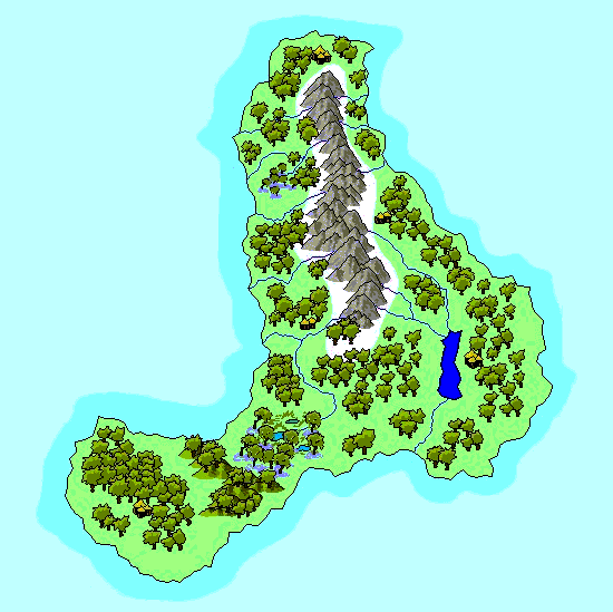
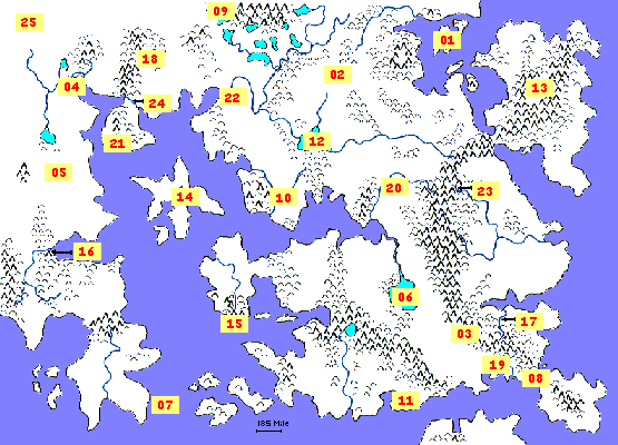
| Darek Isles | |
| | The northwest portion of the Grifteg Sea is filled with some 100,000 islands, known collectively as the
Darek Isles (Darek is Ylthic for "ice pellet"). Some are merely wave-swept rocks poking above the sea, many are large enough to
have their own mountains, lakes and settlements. The largest is "Wolf" (for the many wolves and wargs found there), then "Sno'dyl",
"Kalymat", "Gnyssell" and "Halberg". The map below is of Gnyssell, which has a few small human settlements and
known Gnoll and Ogre camps in the inland heights.
Given the paucity of resources on most of these oft-frigid isles, the Ylthic raiders from the east seldom bother to land here. Which is a good thing.
These islands are nominally claimed by the Kindom of Cadorna, but this is more a lack of contesting claimants, as they expend
little of their precious military in this region. Occasional marine patrols make of the bulk of such activity.
|
| |  |
02
| Ethilfrith Mere | |
| | With no major rivers flowing in or out of this lake, it remains magically fresh and clean. It is crytal clear to remarkable depths, with light
penetrating to over 50m. It is revered by elves as the "heart" of their land Lithorindinum. Rich in aquatic life of all
sorts, anyone touching the waters is subject to death by the elves. |
03
| Crimson Cliffs | |
| | So named for the colour the setting of Solaris often paints these cliffs. It is reputed to be one of the most beautiful sights in
the world. They span almost 300km in length, often more than 600m tall.
While the cliffs are not overly tall, and where the paths are they are little more than 200m in height, the two
paths down the cliff face represent one of the few means of crossing the entire Dolomite Mountain chain aboveground on foot. There once was a pass well to the
north in the Whitefang Range, but it was destoyed during Firefall. Now only one other pass exists, to the south and
east in the Fairweather Range. The two paths down the Crimson Cliffs are not without risks. The southern of the two allows horses to be guided down, and is gentler, but still washed out
and treacherous in parts. The more northerly of the two is more direct and easier to find and follow. In times past, when trade from Ylthic lands was more common, these two paths and the
pass to the south-east were well travelled indeed.
|
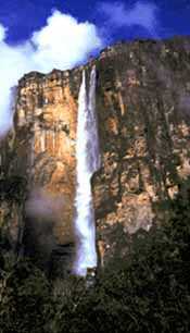
04
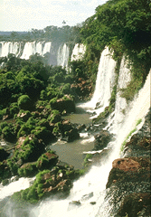
| Winterbred Falls | |
| | The Winterbred is not a mighty river by most measures, but in the spring the runoff creates a massive flow. About 175km upstream from the mouth, it
flows over a broad plateau, where it spreads over over almost 3km of falls. The drop is only 200m or so in most places but the volume is huge. For height it does not compare with
the Tithel Falls, but for sheer grandeur little compares. |
| |  |
05
| Mistvale | |
| | Like a giant crack to the very core of Seteria, Mistvale is a monstrous, yawning valley, over 850 km long and almost 150 km wide at a few points, it is most notable
for its depth and steep walls. In fact, it is almost 4000 m to valley floor from the surrounding plains in most places.
|
06
| Lake Asino | |
| | The largest freshwater body in all of Seteria, it is rich with fish and all manner of aquatic life. It is large enough to moderate the
local temperatures, and provide cooling breezes on the hottest summer days.
|
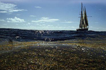
07
| Sargasso Sea | |
| | Along this eastern shore of the Irdriont Arm the Bay of Bornu is quite shallow.
It is also warm and supports a veritable forest of sea weeds and kelp forests. It is home to innumerable creatures,
and unless one knows the correct paths to follow presents a virtually ship-proof barrier to the coast. |
| |  |
08
| Straits of Medosia | |
| | The Sea of Sails is a massive body of water, and its current are channeled between the island of Mendosia
and the bulk of the Trishore continent. The result is currents that can tear many ships apart, even if they manage to not be driven upon
the rocky shores on either side of the 100km-wide strait. The Straits of Mendosia serve as an effective barrier to much trade for the east
coast to the interior of Trishore and the lands about the Firefall Sea. Going around Mendosia is an option, but adds weeks of travel and is
often no safer: many prey on ships that travel around Mendosia and Zakhara.
|
09
| White Peak | |
| | The tallest mountain on all of Seteria. It stands 9192m tall, sheathed
in a permanent crown of snow and ice.
|
10
| Splitting of the Oukranous | |
| | As the Oukranous flows from the hills south of Lake Mured it gathers strength until
half way to its mouth it splits in two. What magic allows half the flow to go further south, and half to go to the
north-west is not clear (whether water elementals, a spell, or so forth), but it has been in effect since Firefall.
The new river that runs to the north-west is called the Crimple River and it is said that those who bathe where the
river splits will never die from drowning.
|
11
| The Quag | |
| | The mightiest swamp in Trishore, The Quag is place of legend. At almost 70,000 square kilometers , it
larger than some countries, and home to everything from dragons to entire raised cities. It came into being as part of the
overall sea-level decrease post Firefall. However, the last 4,000 years have been more than enough time for its pools,
clutching mud, impenetrable forests and terrifying inhabitants to enter the legends of an entire continent.
|
12
| Lake Mured | |
| | Not much smaller than Lake Asino, Lake Mured is shallower and often aligned with the
prevailing winds. Thus, when a storm blows up this 325 km-long lake can create ocean-sized waves. Barges, smaller ships and fishing craft are often lost in
these huge swells which can kick up very quickly.
|
13
| Valley of Tears | |
| | The middle of the Xyrog Peninsula is not only hundreds of kilometers inland from the
oceans around it, but the mountains there (both the Littlefoot Range and the Calandesia Mountains)
surround a large valley. This valley is the Valley of Tears, the dryest desert on Seteria, often bitter cold (with an elevation of over 2000m), and having only one
entrance in the northern end... Other than creatures living the carrion of those unfortunate enough to wander in, there is little here.
This desolation is best captured by thsi quote, "The only water that ever falls here is tears for the dead", an unattributed quote from
an ancient Ylthic tome of the earliest human explorers into this area.
|
14
| Firefall Lake | |
| | Firefall may have been over 4000 years ago, but here its effects are still
vividly present. At the center of Firefall Island is this lake, unimaginatively known as Firefall Lake. Here the
impact is still raw, as the lake steams and boils, sending clouds of steam skywards. Various pools and ponds are
multicoloured with minerals and various tiny creatures. A mere 600m at its deepest, it is scalding hot due to the
magma which still flows in the depths.
|
15
| Chantelor Cliffs | |
| | It may be the winds, but many swear they can hear the cries of those thrown from the top of this 180km-long cliff. The cliffs are at least
800m tall and date from Firefall when the mountain that was here was split in two, with half disappearing into the sea below. The Gulf of Tempet now
laps the bottom of these cliffs.
Those who were thrown from the top were Fire Clan worshippers, who were killed by Psionic Oligarchy
troops. This dates from around 2800 pf to 2810 pf as part of the Race War.
|
16
| Fastwater Peak | |
| | A beautiful sight, Fasterwater Peak stands some 3000m above the valley below, virtually alone and
sentinel-like at the western end of the Vayethian Gulf. The Dewbourne River flows at its feet, furthering the sense that this
peak is alone in its glory.
|
17
| The Ivy Arch | |
| | The Moss River is not particularly fast moving at any time, but higher up near it's source in
the Fairweather Range (at the foot of Ivy Peak), it moves with some force. Millennia ago a landslide drove the Moss River
against a narrow cliff face. It eroded a hole through the cliff, leaving a massive arch. Since then creepers and vines have
covered the arch, creating a huge green vault. It is the largest on Seteria, 300m across at the base, and some 200m tall.
|
18
| Newfire Drop | |
| | Newfire Mountain (6747m asl) has one face which stands above the G'Lingrin Canyon. At this point the canyon
is nearly 2500m deep, and nearly vertical. Thus, from peak to bottom is a drop on this face of almost 9250m, or the largest on Seteria that
is aboveground.
|
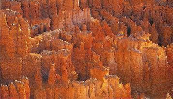
19
| Mirage Desert Rittens | |
| | The Mirage Desert in the Golden Realm of Pelorm is merely dry and sandy to the west. Here, in the eastern reaches
dryness becomes more remarkable. Here, a sand and rock conglomerate has been eroded by rare rains into a maze of narrow valleys, small cliffs and
deep gulleys. Most are no more than 30m deep, but all are very steep and due to their crumbling nature virtually impossible to climb.
The Mirage Desert Rittens are different from the Achintobin Waste on the island of Medosia, in that the clefts and valleys here are wide enough
for humans to walk through (and get lost in and die). There, the plain is disected by little streams that leave narrow channels usually no deeper
than 5'-10' and quite narrow. The Waste is also much wetter and more verdant.
|
| |  |
20
| Amos River | |
| | In dryer months the Amos River reaches this area from its source near Whiteshoulders and the city of Stonewall and simply vanishes into
the sands around it. Then, among the run-off and streams of the Firebrand Mountains its starts up again, eventually wending its way to Urgrik Bay. A river with a
head and a mouth, but no body for many months of the year.
|
21
| Vigskimdam Beach and the Mithral Desert | |
| | Vigskimdam is a shortened common version (but still hard to say) of the original dwarvish name for this remarkable beach. It is over 400km of unbroken
sand, and stretches inland nowhere less than 150km deep. Beyond the shoreline it is known as the Mithral Desert. The original dwarvish name stems from over 2000 years ago, as
they began to explore the mountains in the Melopian Peninsula, and after centuries of work found mithral under Redwing Mountain in 2359 pf. This
lode was depleted in 2597 pf, and the clans that had lived in the area departed after Haz was defeated and throughout the Dry Years.
What makes the beach remarkable beyond its length is its utter barreness, the tricky winds offshore, the difficult currents alongshore, and the uncountable shipwrecks and bleached bones that
line the shore.
|
22
| Wei Marsh and the Tirzon River Delta | |
| | While the Wei Marsh may be best known as the location of the city of Belecost (capital of the Andron
Kingdom), the marsh itself is truly a wonder. It is actually a massive birdsfoot delta, stretching 100s of kilometers in every
direction into Tirzon Bay.
The Tirzon River is on its own a great river, carrying sediment in vast quantities. Add to that the flow of the Silverflow and
other tributaries, it becomes the longest and largest flow river on Seteria. Home to countless birds, aquatic life beyond compare, and
insects that are (in)famous for their quantity and bloodthistiness.
|
23
| Tithel River Falls | |
| | Deep in the Olumneca Mountains, snowmelt forms the source of the Tithel River. Scarcely
50km from its source however, it falls an awesome 1400m. While the flow is not massive at any time, its wind-whipped spray and the staggering height make this
an awesome sight. The Dwarves of the Hillgarth Clans revere this site.
It is a single fall, and while far taller, is quite dissimilar from the Winterbred Falls. |
| |  |
24
| Melop River | |
| | Like the Oukranous River above, the Melop appears to be enchanted as well. However,
in the case of the Melop it is quite clear the sort of magic involved. Exactly half way from its mouths (for it does have two), the current suddenly begins to flow both
east and west. From whence comes this water? A spring? No. Deep in the river is a link to the elemental plane of water. Could there be similar links for other elements?
Quite possibly. But why is this one here, and who or what brought it into being?
|
25
| The Glass Fields | |
| | Never fully explored, the Glass Plains are a massive expanse (many 1000s of kilometers in all directions) of
fused sand and stone. No history speaks of its formation, and no Gods lay claim to it. It has been there for as long as anyone can remember, and
over this time specialized creatures have come to live there. In many places it has cracked or broken, leading to caverns and spaces beneath
this translucent roof. It is inhospitable in the extreme, but there are those who know its ways and are able to live there.
|
 HOME
HOME